Sunday, February 27, 2011

Year 10 Monday 28/2: Summarising the TRESB Project

Year 10 Monday 28/2: Summarising the TRESB Project

Write a blog post (including images) which details (a paragraph for each point):
  1. The problem which lead to the TRESB Project.
  2. The solution to the problem.
  3. The result of the project. What areas were effected and how? Do you think that it was a success?
HW: 7.8 Dune Revegetation at Stuarts Point (Due Tuesday)

Vocab Quiz: Thursday 3/3
Unit Quiz: Monday 7/3
 
1. During the 1950s the entrance to the Tweed River, which is at the southern end of the Gold Coast, became a hazard to shiopping because of sandbars that were forming across the river mouth. The easy solution to this problem was to construct breakwaters to stabilise the river entrance and help keep it clear of sand. While these breakwaters initially fixed the problem for shipping, between 1962 and 1965 they had to be entended eagain due to further sand build up. At that time the long term effects on longshore drift and the supply of sand to the beaches north of the Tweed River were not considered.


2. The breakwater on the southern side of the Tweed River acted to trap sand that would naturally be moved in a northerly direction by longshore drift. The continual build up of sand on the southern side of the breakwater eventually caused the river mouth to once again silt up. It became apparent that continually extending the breakwaters was not the solution to provide a safe entrance to the Tweed River.
 
In an effort to create a safe river entrance and solve the problem of the beaches immediately north of the Tweed being deprived of the natural supply of sand, the accumilating sand at the river mouth was periodically dregded and trucked to the Gold Coast where it was used for beach nourishment.


3. The ongoing operations of TRESBP re being constantly monitored. The local community are frequently consulted, beach profiles are monitored both above and below the water to check on sand pumping activities and breakwaters are monitored for erosion and movement. With many users of the beach there are a range of opinions on the success of the project.
 
Generally the restoration of Gold Coast beaches has been well received by all. Tourists and residents have their beaches back and the Tweed River is safer for sbipping. One criticism of the project has been that the beaches of the area are now too wide. Geographers argue that in years to come the beach widths of the southern Gold Coast will return to a more natural state. Since the project has been completed there have been few major erosion events in the Gold Coast area.


Year 10: Coastal Management - 7.6 The Tweed River Entrance Sand Bypassing Project

1) It became necessary to extend the Tweed River breakwaters because the continual build of sand on the southern side caused the river mouth to silt up again, which meant the entrance wasn't safe to use

2) There wouldn't be any sand to be collected for beach nourishment for the Gold Coast Beaches as there would've been before the breakwaters created as there would be less of a sand buildup. Also, after a severe storm, more sand would be built up along the Southern side of the Tweed River would be a lot more trucking of sand into the Gold Coast which would cost a lot more

3) Due to sandbars constantly forming along the entrance to the Tweed River, ships couldn't enter the River because they would run aground. The natural process is called longshore drift

4) Dredging of the Tweed River was a short term goal as it didn't last long as more and more sand continuously built up and the cost of having to dredge it all out was extremely expensive as it had to be done regularly

5) TRESBP replaced natural longshore drift by shifting the built up sand onto other beaches through pipes so that the sand would nourish other beaches and outlets inside of letting the sand and silt building up on the Tweed River

6) The TRESBP was one of the most successful coastal management schemes because it managed to remove the sand and silt build up on the Tweed River and removed it safely without causing harm to the environment, to other outlets such as West and East Snapper Rocks aswell as dredging to the Gold Coast. It also costs a lot less than constantly dredging to the Gold Coast via massive trucks.

7)

8) Since 1962, the breakwaters at the Tweed River have constantly got larger and larger to prevent the buildup of sand aswell as the money needed to extend breakwaters and maintain the River Entrance.
9) The lengths of breakwaters are roughly 250 metres on the North entrance and 25 metres on the South entrance

Wednesday, February 23, 2011

HOMEWORK – PROFILE ON BIG WAVES

HOMEWORK - Profile on Big Waves - "Jaws" Surf Break Hawaii

Design a blog post on your blog of Maverick waves from different parts of the world. Be sure to describe the geography and the topography of the ocean floor in these areas and how this helps create these massive waves.


"Jaws" is the name given to a big wave surfing reef break on the island of Maui in the U.S. state of Hawaii. It is located on the northern side of the island between mile markers 13 and 14 on the Hana highway and sits at the base of rolling sugar cane field hills. The exact location is represented in the diagram above.


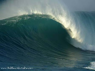
The surf break, a deep water reef break, is called "Jaws" due to the size and ferocity of the waves. The waves at "Jaws" can reach heights of 120 ft (36.6 m) on the face of the wave, moving as fast as 30 mph (48.3 km/h).

The Jaws surf break is the home of tow-in surfing and has reached its worldwide watersports fame largely due to the frequent filming and photography of tow-in surfing legends performing there on enormous ocean waves breaking at the deep reef off the shore; famed big wave surfers such as tow-in surfing pioneers (also known as "The Strapped Crew"-for the rubber straps on their short surfboards to anchor their feet against the forces) notably Laird Hamilton and Dave Kalama.


In order for the surf at "Jaws" to reach its extreme heights, many specific ocean and weather conditions must prevail concurrently. Because ocean swells large enough to produce this kind of surf occur only during winter months, primarily between December and February, they typically coincide with very strong winds which have a large effect on the surf. Other swells, particularly the small but powerful trade wind swells, can make the surf choppy and difficult to ride. There are several other surf spots around the world that boast similar wave heights; however, "Jaws" is famous for its wave forming quality. The reef and rocks at "Jaws" are shaped in a way that magnify incoming swell energy and produce clean and well defined right and left-directional waves with gigantic barreling (hollow, air-filled wave interior) sections

As you can see the Surf Reports go to great detail to ensure surfers have enough information about the break at all times. This can help stay safe in the surf, going out when the winds aren’t at full velocity and staying in when they are. They also provide an extensive long range forecast.  


Big Wave Rating

Height
Period
Dir
Wind (Gust)
Weather
Wed
23/02  
6am

6.5ft
11secs
9
12
mph
23c
 
Noon

6.5ft
10secs
8
9
mph
24c
 
6pm

6ft
15secs
7
8
mph
23c
Thu
24/02  
6am

5.5ft
9secs
3
2
mph
22c
 
Noon

5.5ft
9secs
6
6
mph
24c
 
6pm

5.5ft
8secs
10
11
mph
22c
Fri
25/02  
6am

5ft
8secs
5
6
mph
22c
 
Noon

5ft
11secs
7
7
mph
24c
 
6pm

5ft
11secs
5
5
mph
23c


Although this is just a sample, the same table is provided for dates months away which can also give surfers vital information about when it is safe and not safe to surf the break. Generally the higher the wind strength the higher the sets are going to be