9.1 Questions
1. What is meant by the term "Urban Sprawl"? The uncontrollable spread of urban development into neighbouring regions.
2.What is meant by the term "Urban Consolidation"? Land within an existing city's boundary is developed with high-rise apartments complexes, townhouses and villa developments.
3.What is meant by a highly urbanised country? Where the majority of the population lives in urban areas.
4. List three statistics that suggest Australia is a higly urbanised country? Has a high population density, not tolerable conditions apart from urban areas and most employment is in the major centres.
5.What factors have influenced the location of Australia's capital cities? A high population density, a high proportion of the population working in manufacturing and/or professional or service related industries and they are centres of business, trade, tourism, entertainment and finance.
6.What is popultion density and how is it related to urban sprawl? The number of people living per unit of an area and it is related to urban sprawl as it shows how many people live in each region.
7.How do Australian cities compare to other cities in the world in terms of their population density? They have very small population density compared to many other cities around the world such as Cairo or Paris.
8.Describe the advantage, in terms of the provision of infrastructure, urban consolidation has over urban sprawl? It shows that you can have a dense population at a such a small area as in high-rise apartments. More facilities can be available but using less space.
9.How have urban planners responderd to the issue of urban sprawl in Australia? Urban planners have had to be innovative in their design of apartments and new estates to manage the impacts of population growth in cities
10. a) Which Australian City covers the greatest land area? Melbourne
b) Describe how population density is calculated? It is calculated by dividing population by land area
c) Rank Australia's cities in terms of their population density . Sydney, Melbourne, Adelaide, Wollongong, Perth, Gold Coast, Newcastle, Canberra, Brisbane, Gosford
11. Discuss the opinions the residents in the detatched housing in the foreground might have to the apartment buildings being constructed. What impact will the construction have on their community. The construction will have a large impact as it will greatly oveshadow the smaller houses around the large apartment developments. They will cause about 75% increase in the number of people living in that area. It will also cause shadowing over the smaller houses as the apartment buildings are so large and bulky.
12. Discuss the advantages and disadvantages of living in a detached style housing estate compared to apartment living. A detached house will be better to live in as you have more room to go around and more freedom than compared to an apartment building where you are cramped into a little room with about 100 other people in the same building. It allows there to be more space and make people less stressed as it has more freedom.
Sunday, March 13, 2011

Urban Renewal Vocab
Urban Renewal Vocab
Aesthetics - The appreciation of, and sensitivity towards, works of art, designs, products, objects or artifacts. An example is the aesthetics of a building. This example relates to the word as people's feelings and mindset change around the relative looks of a building, inside and outside. If its a warm, colorful and well presented building, people will feel more at home and more comfortable. If its a run-down, rotting building, people will be anxious and uncomfortable.
Safety - The condition of being protected against physical, social, spiritual, financial, political, emotional, occupational, psychological, educational or other types or consequences. An example is OH&S regulations. OH&S regulations ensure the wellbeing of a person in the outdoors or the workplace. This relates to safety as the person would be safe from most types of harm, especially physical
Slums - A district of a city marked by poverty and inferior living conditions. An example is a third world area or overpopulated city such as Mumbai. Mumbai's living conditions include 55% of people living in a slum within a 6% area of Mumbai's living space. Slum growth rate is much higher than urban growth.
Decay - The organic phenomenon of rotting. A badly maintained house is an example of decay. This relates to the word as a house that isn't maintained properly would have termites, fungus, collapsing supports and items. This would be uncomfortable for the resident
Reconstruction and renewal - Turning an area to become hospitable or able to be cultivated. A slum would be an example as it would have to be renewed of its waste, decay and poor living conditions to be made properly hospitable and cultivated.
Transport - Moving something or somebody around from one place to the other. An example is public transport. This allows people to catch buses, ferries or trains to get from one place to another easily
Suburbanization - A term used to describe the growth of areas on the fringes of major cities. It is one of the many causes of the increase in urban sprawl. An example is Surry Hills, where the growth of population in that area has increased greatly over the years. In this case, there was no urban sprawl and the area has been increased in value and average income of each resident
Environmental Factors - Factors in the environment that may have an effect on our development or growth eg diet, atmospheric pollutants, cigarette smoke, preservatives, X-rays. These are linked as they would change the way people would consider about living or going to an area. E.g. Going to King's Cross at night or going to Hornsby is clear example as many people would rather Hornsby because of King's Cross' reputation.
Light and Sound - Factors which are technically environmental as they affect the outlook of an area greatly. An example is urbanization and developing of technology. As technology and vehicles such as trains are introduced or used more often, would create much more sound than a regular area with no trains. Light would be a factor as lighting or the brightness (sunlight) of an area would affect people's moods and feelings about that particular place
Aesthetics - The appreciation of, and sensitivity towards, works of art, designs, products, objects or artifacts. An example is the aesthetics of a building. This example relates to the word as people's feelings and mindset change around the relative looks of a building, inside and outside. If its a warm, colorful and well presented building, people will feel more at home and more comfortable. If its a run-down, rotting building, people will be anxious and uncomfortable.
Safety - The condition of being protected against physical, social, spiritual, financial, political, emotional, occupational, psychological, educational or other types or consequences. An example is OH&S regulations. OH&S regulations ensure the wellbeing of a person in the outdoors or the workplace. This relates to safety as the person would be safe from most types of harm, especially physical
Slums - A district of a city marked by poverty and inferior living conditions. An example is a third world area or overpopulated city such as Mumbai. Mumbai's living conditions include 55% of people living in a slum within a 6% area of Mumbai's living space. Slum growth rate is much higher than urban growth.
Decay - The organic phenomenon of rotting. A badly maintained house is an example of decay. This relates to the word as a house that isn't maintained properly would have termites, fungus, collapsing supports and items. This would be uncomfortable for the resident
Reconstruction and renewal - Turning an area to become hospitable or able to be cultivated. A slum would be an example as it would have to be renewed of its waste, decay and poor living conditions to be made properly hospitable and cultivated.
Transport - Moving something or somebody around from one place to the other. An example is public transport. This allows people to catch buses, ferries or trains to get from one place to another easily
Suburbanization - A term used to describe the growth of areas on the fringes of major cities. It is one of the many causes of the increase in urban sprawl. An example is Surry Hills, where the growth of population in that area has increased greatly over the years. In this case, there was no urban sprawl and the area has been increased in value and average income of each resident
Environmental Factors - Factors in the environment that may have an effect on our development or growth eg diet, atmospheric pollutants, cigarette smoke, preservatives, X-rays. These are linked as they would change the way people would consider about living or going to an area. E.g. Going to King's Cross at night or going to Hornsby is clear example as many people would rather Hornsby because of King's Cross' reputation.
Light and Sound - Factors which are technically environmental as they affect the outlook of an area greatly. An example is urbanization and developing of technology. As technology and vehicles such as trains are introduced or used more often, would create much more sound than a regular area with no trains. Light would be a factor as lighting or the brightness (sunlight) of an area would affect people's moods and feelings about that particular place
Sunday, March 6, 2011
7.8 Dune Revegetation at Stuarts Point
7.8 Dune Revegetation at Stuarts Point
1. Name and locate the coastal dune management area discussed in this unit.
The area discussed in this unit is Stuarts Point. Stuarts Point is located at the mouth of the Macleay River just south of Grassy Head headland and North of Shark Island and South West Rocks.
2. Using the material in the unit, construct a timeline that highlights the changes in the Stuarts Point sand dune ecosystem.
1893 - A large flood opened up a gap for the Macleay River at South West Rocks causing the original mouth of the Macleay River to close due to build up of silt and lessen in flow.
Early 1900's - The gap closed allowing cattle to graze along the dune barrier system. Eventually the vegetation was lost and on three consecutive occasions of heavy storms the dunes were drowned. The idea of the dunes being lost caused action from the community as there was threat against some property.
1965 - After approaching the Soil Conservation Service of New South Wales for advice and assistance, they provided native plant seedlings to what was going to be the start of the revegetation program for Stuarts Point. Unfortunately, this scheme failed in August due to cattle grazing.
1970 - With all the organisations working together, they developed a scheme that would re-establish the dunes in three parts. They would have a primary dune consisting of grasses and creepers, a secondary species consisting of shrubs and short-lived trees and a tertiary species consisting of long-lived trees.
Today - It continues to be a success today with the plan still intact and very few issues.
3. Describe the role of the local community in managing the sand dune area.
The community had a large role in making the management of the sand dunes successful. They had the responsibility to keep on the walking tracks, keep litter to a minimum and some people from the communities even volunteered. Their involvement was a key area of the re-establishment of Stuarts Point.
4. Why is the sand dune area important to the people of Stuarts Point?
The dune area is very important to the the people of Stuarts Point. Without it, some properties would be lost making it almost crucial to have the dunes in place.
5. Using 7.35 describe the natural vegetation succession on sand dunes.
The sand dunes are built up of three separate and different plant types. The first section being made up of grasses and creepers that trap dry sand in the frontal dunes and reduce the sand and spray onto dunes behind it. The second section is made up of shrubs and short lived trees that are highly adapted prolific re-seeders, fast-growing plants. Finally the third section is made up of long-lived trees that are permanent, highly interdependent, surviving in protection of dune and secondary species.
6. Explain why vegetation is so important in stabilising sand dunes.
Vegetation is important in stabilising sand dunes as it stops the wind from blowing the sand away and keeps the sand firm from being washed away by long shore transportation.
7. What impact did cattle grazing have on the sand dune area?Cattle grazing meant that the vegetation was lost and therefore the were no longer any plants to keep it firm/strong.
8. Describe the changes to the sand dune area that would have occurred after cattle grazing. Identify the geographical processes that would have been altered as a result of the removal of vegetation from the dunes.
The sand dune would have become less dense or firm and there would be great loss of sand due the the natural process of long shore transportation.
9. Identify the groups involved in the rehabilitation program.
The groups involved in the rehabilitation of the sand dune were the Department of Lands, the Department of Public Works, the Macleay Shire Council and he Soil Conservation Service of New South Wales.
10. Outline the stages involved in the management program undertaken to re-establish the coastal vegetation. The stages taken to re-establish the coastal vegetation included; using a tractor to form a small foredune, then they planted trees along the river band, then they planted the native seedlings between the foredune and the river band and finally once the plants were established coastal tertiary species.
12. Use maps to explain the geographical process that would have caused the river mouth to silt up.
The geographical processes that would have caused the Macleay River to silt up include; long shore transportation from the southern parts of the beach as well as wave refraction because the beach faces east.
13. Evaluate the success of the revegation program in the following areas:
a) Stabilising the sand dunes. The stabilising of sand dunes through revegetation was an enormous success as the sand dunes are still standing strong. By using a multi-part system they made a successful stabilised dune.
b) Protecting the Macleay River ecosystem. The success of protecting the Macleay River ecosystem was very true, they managed to replant native bushes and trees without causing harm to the dune system. They only issue was that Bitou Bush, a toxic weed that spread all of the fore and hind dunes.
c) Benefiting groups from the local community. The community benefited immensely from this project. They now had a clear pathway which occasionally needs maintenance and a sand barrier to protect some properties.
The area discussed in this unit is Stuarts Point. Stuarts Point is located at the mouth of the Macleay River just south of Grassy Head headland and North of Shark Island and South West Rocks.
2. Using the material in the unit, construct a timeline that highlights the changes in the Stuarts Point sand dune ecosystem.
1893 - A large flood opened up a gap for the Macleay River at South West Rocks causing the original mouth of the Macleay River to close due to build up of silt and lessen in flow.
Early 1900's - The gap closed allowing cattle to graze along the dune barrier system. Eventually the vegetation was lost and on three consecutive occasions of heavy storms the dunes were drowned. The idea of the dunes being lost caused action from the community as there was threat against some property.
1965 - After approaching the Soil Conservation Service of New South Wales for advice and assistance, they provided native plant seedlings to what was going to be the start of the revegetation program for Stuarts Point. Unfortunately, this scheme failed in August due to cattle grazing.
1970 - With all the organisations working together, they developed a scheme that would re-establish the dunes in three parts. They would have a primary dune consisting of grasses and creepers, a secondary species consisting of shrubs and short-lived trees and a tertiary species consisting of long-lived trees.
Today - It continues to be a success today with the plan still intact and very few issues.
3. Describe the role of the local community in managing the sand dune area.
The community had a large role in making the management of the sand dunes successful. They had the responsibility to keep on the walking tracks, keep litter to a minimum and some people from the communities even volunteered. Their involvement was a key area of the re-establishment of Stuarts Point.
4. Why is the sand dune area important to the people of Stuarts Point?
The dune area is very important to the the people of Stuarts Point. Without it, some properties would be lost making it almost crucial to have the dunes in place.
5. Using 7.35 describe the natural vegetation succession on sand dunes.
The sand dunes are built up of three separate and different plant types. The first section being made up of grasses and creepers that trap dry sand in the frontal dunes and reduce the sand and spray onto dunes behind it. The second section is made up of shrubs and short lived trees that are highly adapted prolific re-seeders, fast-growing plants. Finally the third section is made up of long-lived trees that are permanent, highly interdependent, surviving in protection of dune and secondary species.
6. Explain why vegetation is so important in stabilising sand dunes.
Vegetation is important in stabilising sand dunes as it stops the wind from blowing the sand away and keeps the sand firm from being washed away by long shore transportation.
7. What impact did cattle grazing have on the sand dune area?Cattle grazing meant that the vegetation was lost and therefore the were no longer any plants to keep it firm/strong.
8. Describe the changes to the sand dune area that would have occurred after cattle grazing. Identify the geographical processes that would have been altered as a result of the removal of vegetation from the dunes.
The sand dune would have become less dense or firm and there would be great loss of sand due the the natural process of long shore transportation.
9. Identify the groups involved in the rehabilitation program.
The groups involved in the rehabilitation of the sand dune were the Department of Lands, the Department of Public Works, the Macleay Shire Council and he Soil Conservation Service of New South Wales.
10. Outline the stages involved in the management program undertaken to re-establish the coastal vegetation. The stages taken to re-establish the coastal vegetation included; using a tractor to form a small foredune, then they planted trees along the river band, then they planted the native seedlings between the foredune and the river band and finally once the plants were established coastal tertiary species.
12. Use maps to explain the geographical process that would have caused the river mouth to silt up.
The geographical processes that would have caused the Macleay River to silt up include; long shore transportation from the southern parts of the beach as well as wave refraction because the beach faces east.
13. Evaluate the success of the revegation program in the following areas:
a) Stabilising the sand dunes. The stabilising of sand dunes through revegetation was an enormous success as the sand dunes are still standing strong. By using a multi-part system they made a successful stabilised dune.
b) Protecting the Macleay River ecosystem. The success of protecting the Macleay River ecosystem was very true, they managed to replant native bushes and trees without causing harm to the dune system. They only issue was that Bitou Bush, a toxic weed that spread all of the fore and hind dunes.
c) Benefiting groups from the local community. The community benefited immensely from this project. They now had a clear pathway which occasionally needs maintenance and a sand barrier to protect some properties.
Sunday, February 27, 2011
Year 10 Monday 28/2: Summarising the TRESB Project
Year 10 Monday 28/2: Summarising the TRESB Project
Write a blog post (including images) which details (a paragraph for each point):


Write a blog post (including images) which details (a paragraph for each point):
- The problem which lead to the TRESB Project.
- The solution to the problem.
- The result of the project. What areas were effected and how? Do you think that it was a success?
HW: 7.8 Dune Revegetation at Stuarts Point (Due Tuesday)
Vocab Quiz: Thursday 3/3
Unit Quiz: Monday 7/3
Vocab Quiz: Thursday 3/3
Unit Quiz: Monday 7/3
1. During the 1950s the entrance to the Tweed River, which is at the southern end of the Gold Coast, became a hazard to shiopping because of sandbars that were forming across the river mouth. The easy solution to this problem was to construct breakwaters to stabilise the river entrance and help keep it clear of sand. While these breakwaters initially fixed the problem for shipping, between 1962 and 1965 they had to be entended eagain due to further sand build up. At that time the long term effects on longshore drift and the supply of sand to the beaches north of the Tweed River were not considered.
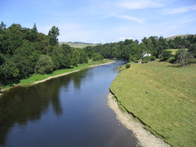
2. The breakwater on the southern side of the Tweed River acted to trap sand that would naturally be moved in a northerly direction by longshore drift. The continual build up of sand on the southern side of the breakwater eventually caused the river mouth to once again silt up. It became apparent that continually extending the breakwaters was not the solution to provide a safe entrance to the Tweed River.
In an effort to create a safe river entrance and solve the problem of the beaches immediately north of the Tweed being deprived of the natural supply of sand, the accumilating sand at the river mouth was periodically dregded and trucked to the Gold Coast where it was used for beach nourishment.

3. The ongoing operations of TRESBP re being constantly monitored. The local community are frequently consulted, beach profiles are monitored both above and below the water to check on sand pumping activities and breakwaters are monitored for erosion and movement. With many users of the beach there are a range of opinions on the success of the project.
Generally the restoration of Gold Coast beaches has been well received by all. Tourists and residents have their beaches back and the Tweed River is safer for sbipping. One criticism of the project has been that the beaches of the area are now too wide. Geographers argue that in years to come the beach widths of the southern Gold Coast will return to a more natural state. Since the project has been completed there have been few major erosion events in the Gold Coast area.

Year 10: Coastal Management - 7.6 The Tweed River Entrance Sand Bypassing Project
1) It became necessary to extend the Tweed River breakwaters because the continual build of sand on the southern side caused the river mouth to silt up again, which meant the entrance wasn't safe to use
2) There wouldn't be any sand to be collected for beach nourishment for the Gold Coast Beaches as there would've been before the breakwaters created as there would be less of a sand buildup. Also, after a severe storm, more sand would be built up along the Southern side of the Tweed River would be a lot more trucking of sand into the Gold Coast which would cost a lot more
3) Due to sandbars constantly forming along the entrance to the Tweed River, ships couldn't enter the River because they would run aground. The natural process is called longshore drift
4) Dredging of the Tweed River was a short term goal as it didn't last long as more and more sand continuously built up and the cost of having to dredge it all out was extremely expensive as it had to be done regularly
5) TRESBP replaced natural longshore drift by shifting the built up sand onto other beaches through pipes so that the sand would nourish other beaches and outlets inside of letting the sand and silt building up on the Tweed River
6) The TRESBP was one of the most successful coastal management schemes because it managed to remove the sand and silt build up on the Tweed River and removed it safely without causing harm to the environment, to other outlets such as West and East Snapper Rocks aswell as dredging to the Gold Coast. It also costs a lot less than constantly dredging to the Gold Coast via massive trucks.
7)

8) Since 1962, the breakwaters at the Tweed River have constantly got larger and larger to prevent the buildup of sand aswell as the money needed to extend breakwaters and maintain the River Entrance.
9) The lengths of breakwaters are roughly 250 metres on the North entrance and 25 metres on the South entrance
2) There wouldn't be any sand to be collected for beach nourishment for the Gold Coast Beaches as there would've been before the breakwaters created as there would be less of a sand buildup. Also, after a severe storm, more sand would be built up along the Southern side of the Tweed River would be a lot more trucking of sand into the Gold Coast which would cost a lot more
3) Due to sandbars constantly forming along the entrance to the Tweed River, ships couldn't enter the River because they would run aground. The natural process is called longshore drift
4) Dredging of the Tweed River was a short term goal as it didn't last long as more and more sand continuously built up and the cost of having to dredge it all out was extremely expensive as it had to be done regularly
5) TRESBP replaced natural longshore drift by shifting the built up sand onto other beaches through pipes so that the sand would nourish other beaches and outlets inside of letting the sand and silt building up on the Tweed River
6) The TRESBP was one of the most successful coastal management schemes because it managed to remove the sand and silt build up on the Tweed River and removed it safely without causing harm to the environment, to other outlets such as West and East Snapper Rocks aswell as dredging to the Gold Coast. It also costs a lot less than constantly dredging to the Gold Coast via massive trucks.
7)


8) Since 1962, the breakwaters at the Tweed River have constantly got larger and larger to prevent the buildup of sand aswell as the money needed to extend breakwaters and maintain the River Entrance.
9) The lengths of breakwaters are roughly 250 metres on the North entrance and 25 metres on the South entrance
Wednesday, February 23, 2011
HOMEWORK – PROFILE ON BIG WAVES
HOMEWORK - Profile on Big Waves - "Jaws" Surf Break Hawaii

"Jaws" is the name given to a big wave surfing reef break on the island of Maui in the U.S. state of Hawaii. It is located on the northern side of the island between mile markers 13 and 14 on the Hana highway and sits at the base of rolling sugar cane field hills. The exact location is represented in the diagram above.
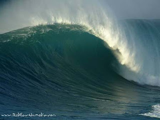
The surf break, a deep water reef break, is called "Jaws" due to the size and ferocity of the waves. The waves at "Jaws" can reach heights of 120 ft (36.6 m) on the face of the wave, moving as fast as 30 mph (48.3 km/h).
As you can see the Surf Reports go to great detail to ensure surfers have enough information about the break at all times. This can help stay safe in the surf, going out when the winds aren’t at full velocity and staying in when they are. They also provide an extensive long range forecast.
Design a blog post on your blog of Maverick waves from different parts of the world. Be sure to describe the geography and the topography of the ocean floor in these areas and how this helps create these massive waves.
"Jaws" is the name given to a big wave surfing reef break on the island of Maui in the U.S. state of Hawaii. It is located on the northern side of the island between mile markers 13 and 14 on the Hana highway and sits at the base of rolling sugar cane field hills. The exact location is represented in the diagram above.
The surf break, a deep water reef break, is called "Jaws" due to the size and ferocity of the waves. The waves at "Jaws" can reach heights of 120 ft (36.6 m) on the face of the wave, moving as fast as 30 mph (48.3 km/h).
The Jaws surf break is the home of tow-in surfing and has reached its worldwide watersports fame largely due to the frequent filming and photography of tow-in surfing legends performing there on enormous ocean waves breaking at the deep reef off the shore; famed big wave surfers such as tow-in surfing pioneers (also known as "The Strapped Crew"-for the rubber straps on their short surfboards to anchor their feet against the forces) notably Laird Hamilton and Dave Kalama.

In order for the surf at "Jaws" to reach its extreme heights, many specific ocean and weather conditions must prevail concurrently. Because ocean swells large enough to produce this kind of surf occur only during winter months, primarily between December and February, they typically coincide with very strong winds which have a large effect on the surf. Other swells, particularly the small but powerful trade wind swells, can make the surf choppy and difficult to ride. There are several other surf spots around the world that boast similar wave heights; however, "Jaws" is famous for its wave forming quality. The reef and rocks at "Jaws" are shaped in a way that magnify incoming swell energy and produce clean and well defined right and left-directional waves with gigantic barreling (hollow, air-filled wave interior) sections
As you can see the Surf Reports go to great detail to ensure surfers have enough information about the break at all times. This can help stay safe in the surf, going out when the winds aren’t at full velocity and staying in when they are. They also provide an extensive long range forecast.
Big Wave Rating | Height | Period | Dir | Wind (Gust) | Weather | |||||||||
Wed 23/02 | 6am | 6.5ft | 11secs |
| 23c | |||||||||
Noon | 6.5ft | 10secs |
| 24c | ||||||||||
6pm | 6ft | 15secs |
| 23c | ||||||||||
Thu 24/02 | 6am | 5.5ft | 9secs |
| 22c | |||||||||
Noon | 5.5ft | 9secs |
| 24c | ||||||||||
6pm | 5.5ft | 8secs |
| 22c | ||||||||||
Fri 25/02 | 6am | 5ft | 8secs |
| 22c | |||||||||
Noon | 5ft | 11secs |
| 24c | ||||||||||
6pm | 5ft | 11secs |
| 23c | ||||||||||
Although this is just a sample, the same table is provided for dates months away which can also give surfers vital information about when it is safe and not safe to surf the break. Generally the higher the wind strength the higher the sets are going to be
Subscribe to:
Posts (Atom)